Today is really July 13th and I thought I would just bring everyone up to date. I will still continue the blog on our BC trip also.
After our BC trip we arrived home on June 27th after a long day of driving 470 miles. Home for two days washing clothes and getting ready for our next outing. We left home on the evening of June 30th heading to Baker City to meet up with some other Airstream folks. We left in the evening because we were taking I-90 and there is a place we like to stay over night at exit 93 behind a small family run fruit stand. Several years ago they said we could park in the back. The following morning to Baker City Oregon for a Rally with about 70 other Airstreamers. After Baker City then over to Joseph to the Wallowa Lake State Park for a few days. Beautiful place. Then on to a state park in Mt Vernon (John Day area) I don't remember the name of right now. Then on to Prineville, and finally on to Redmond Oregon for the Good Sam Rally. We have never been to a Good Sam Rally. We are looking for a couple of items here; a solar system and a Dish. We have been without a TV since about March which is just fine with me but Joe likes TV and occasionally we like to listen to the news.
Just a quick note of were we have been lately. Pictures later.
Safe travels to all
Wednesday, July 13, 2011
Tuesday, July 12, 2011
Hazelton
June 12 & 13
Prince Rupert was our furthermost destination. Now we will back track a bit and travel back to Hazelton 175 miles. Here we stayed at the K'san Historical Village and living museum of the Gitxsan people. To get there we crossed the Hagwilget Suspension Bridge; a single lane bridge, one of North America's highest suspension bridges. The bridge passes over a canyon over the Bulkley River which then goes into the Skeena River. Here we were able to tour the Gitxsan village and see several of the restored tribal houses.
 The confluence of the Bulkley and Skeena Rivers, muddy still from the high water they had this spring
 The single lane suspension bridge


Prince Rupert was our furthermost destination. Now we will back track a bit and travel back to Hazelton 175 miles. Here we stayed at the K'san Historical Village and living museum of the Gitxsan people. To get there we crossed the Hagwilget Suspension Bridge; a single lane bridge, one of North America's highest suspension bridges. The bridge passes over a canyon over the Bulkley River which then goes into the Skeena River. Here we were able to tour the Gitxsan village and see several of the restored tribal houses.
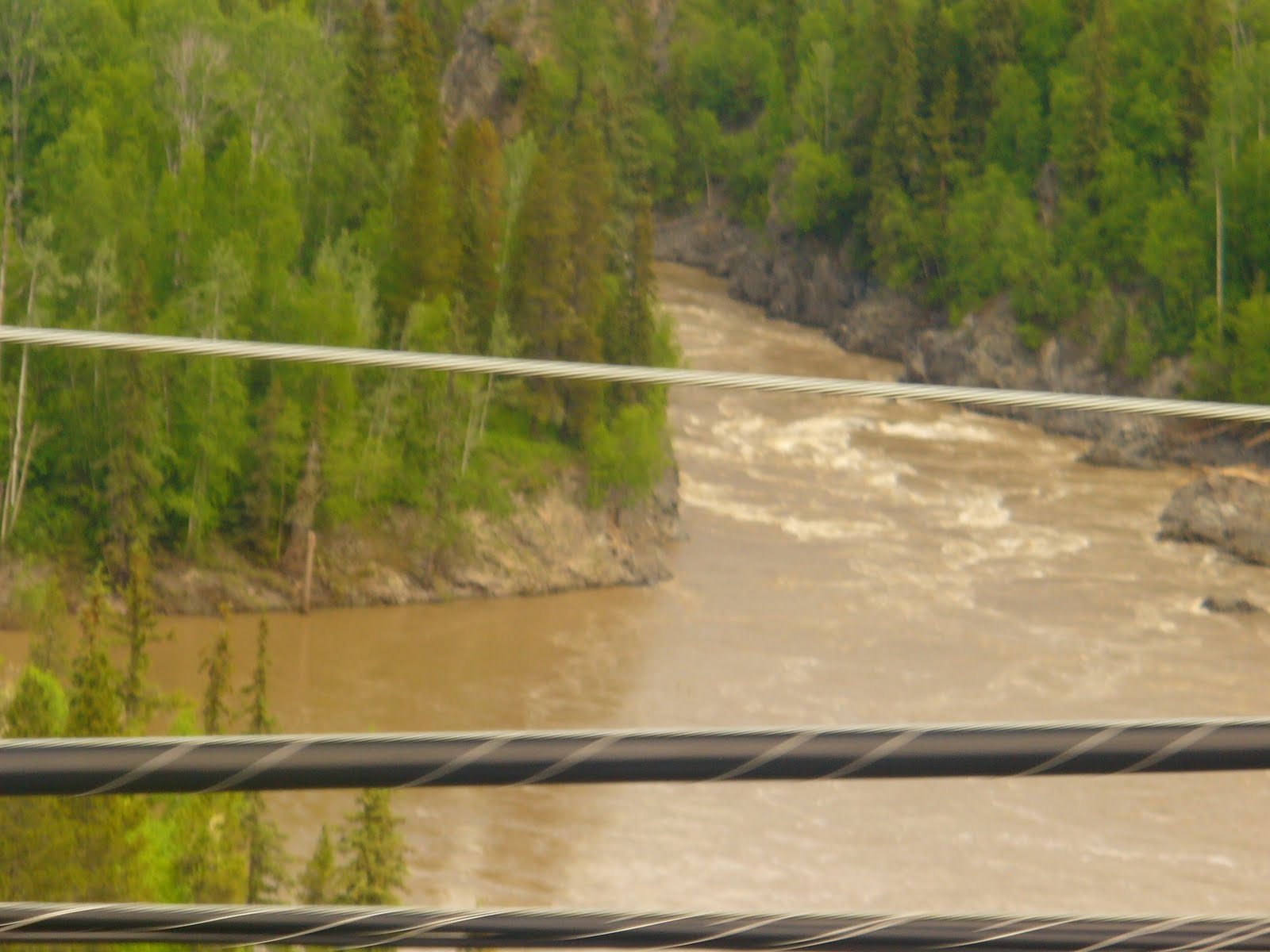 The confluence of the Bulkley and Skeena Rivers, muddy still from the high water they had this spring
 The single lane suspension bridge

We had a wonderful tour, however we were not allowed to take pictures inside. Well worth stopping for a night or two and then take the tour. Great gift shop also.
While we were here we also took a drive out to several villages and saw many totem poles
Safe travels to all

Monday, July 11, 2011
Prince Rupert
June 8, 9, 10, 11, & 12 (Only a little behind)
The secenery on the way to Prince Rupert was stunning, many water falls and the road mainly followed the Skeena River.


We have been told that Prince Rupert gets about 7 days of sun a year. While we were there they had about 3 days of sun and the other days were just a little overcast. We stayed in Kinnikinnick Campground which is actually in Port Edward, about three miles east of Prince Rupert. Port Edward was famous for 200 canneries operating during the boom of the fishing industry. Now it is The North Pacific Historic Fishing Village and is a National Historic Site. The main canery building now has antique belt-driven equipment.
Crossing the bridge from Port Edward to Prince Rupert

We were here for five days so some folks could take a side trip to Haida Gwaii which was about a six hr ferry ride. AKA Charolette Island. We did not go there, but others did and they had a good interesting time.
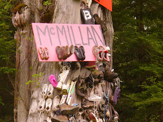
On the way to Prince Rupert was a shoe tree. This was a big cedar tree and people and families have nailed their shoes to the tree. Not sure of the significance of this. I've seen trees where people have tied their shoes together and then threw them up over a branch, but these look like they are nailed to the tree, and some look like they are shoes from a family. Anyway I thought it was kind of funny.

While in Prince Rupert they had their annual Fish Festival with a fantastic parade. Everyone for 200 miles around was either in the parade, watching the parade, or selling food. I love these kind of small town parades.


Prince Rupert's main tourist area, Cow Bay, is cute, quaint and on the waterfront close to downtown. Many places were decorated with cows. Click on the picture below to see a larger picture and you can read the history of Cow Bay.


 Notice the stool with udder

Safe Travels to all
The secenery on the way to Prince Rupert was stunning, many water falls and the road mainly followed the Skeena River.


We have been told that Prince Rupert gets about 7 days of sun a year. While we were there they had about 3 days of sun and the other days were just a little overcast. We stayed in Kinnikinnick Campground which is actually in Port Edward, about three miles east of Prince Rupert. Port Edward was famous for 200 canneries operating during the boom of the fishing industry. Now it is The North Pacific Historic Fishing Village and is a National Historic Site. The main canery building now has antique belt-driven equipment.
Crossing the bridge from Port Edward to Prince Rupert

We were here for five days so some folks could take a side trip to Haida Gwaii which was about a six hr ferry ride. AKA Charolette Island. We did not go there, but others did and they had a good interesting time.
On the way to Prince Rupert was a shoe tree. This was a big cedar tree and people and families have nailed their shoes to the tree. Not sure of the significance of this. I've seen trees where people have tied their shoes together and then threw them up over a branch, but these look like they are nailed to the tree, and some look like they are shoes from a family. Anyway I thought it was kind of funny.


While in Prince Rupert they had their annual Fish Festival with a fantastic parade. Everyone for 200 miles around was either in the parade, watching the parade, or selling food. I love these kind of small town parades.


Prince Rupert's main tourist area, Cow Bay, is cute, quaint and on the waterfront close to downtown. Many places were decorated with cows. Click on the picture below to see a larger picture and you can read the history of Cow Bay.


 Notice the stool with udder
Safe Travels to all
New Aiyansh
New Aiyansh (sounds like ranch without the r ) is the largest of the communities of Nisga'a First Nation. It is near the Nass River just north of Terrace. Tther communities that make up the Nass Valley and the Nisga'a territory ar Greenville, and Canyon City.


We stayed for two nights at the Nisga'a Memorial Lava Bed Provincial Park. About 250 years ago the volcano erupted, killing approximately 2,000 people creating a pocked lava plain. As the lava spilled from the crated it followed a creek bed down slop to Lava Lake and down the Tseax Valley to the Nass River. The volcano was not a mountain, the lava just bubbled up and then created a cone. Several of us hiked to the top of the cone with a guide through a beautiful forest that was not touched by lava but had a layer of black ash. Then a little down the way and we would be in the lava area. This area is incredible with lava flows in and out of the forest. We had to be careful to stay on the trail as there were many pocked areas of water in the lava and if you were in a thin area you would just fall through.

 The lady in the blue is Kay, 88 years young, she goes everywhere and does everything. Kay and Ron just celebrated their 61st aniversarry, Ron is on the far left holding the camera.


 Bark of a Black Cottonwood
 While at the Provincial Park we also visited Canyon City and the Gitwinksihkw Band, above is a bridgew crossing the Nass River on the way to their village
 They used this fish wheel
 Next is Gingolx aka Greenville. I thought this was a great sign at their church. Since all these tribes or Bands are right on the river everyone fishes and dries their salmon. All the areas we visited people came to talk to us to find out who we were and where we were from. Everyone was very friendly and very talkative
 This is in front of every school representing the different bands of their area. This is the Frog, Killer Whale, Raven and Bear


We stayed for two nights at the Nisga'a Memorial Lava Bed Provincial Park. About 250 years ago the volcano erupted, killing approximately 2,000 people creating a pocked lava plain. As the lava spilled from the crated it followed a creek bed down slop to Lava Lake and down the Tseax Valley to the Nass River. The volcano was not a mountain, the lava just bubbled up and then created a cone. Several of us hiked to the top of the cone with a guide through a beautiful forest that was not touched by lava but had a layer of black ash. Then a little down the way and we would be in the lava area. This area is incredible with lava flows in and out of the forest. We had to be careful to stay on the trail as there were many pocked areas of water in the lava and if you were in a thin area you would just fall through.

 The lady in the blue is Kay, 88 years young, she goes everywhere and does everything. Kay and Ron just celebrated their 61st aniversarry, Ron is on the far left holding the camera.


The streams were flooded as this was a very snowy and wet year
 Bark of a Black Cottonwood
 While at the Provincial Park we also visited Canyon City and the Gitwinksihkw Band, above is a bridgew crossing the Nass River on the way to their village
  They used this fish wheel
 Next is Gingolx aka Greenville. I thought this was a great sign at their church. Since all these tribes or Bands are right on the river everyone fishes and dries their salmon. All the areas we visited people came to talk to us to find out who we were and where we were from. Everyone was very friendly and very talkative
  This is in front of every school representing the different bands of their area. This is the Frog, Killer Whale, Raven and Bear
 On our way back to camp we came across this friendly little guy.
Subscribe to:
Posts (Atom)